Into the Southwest
Here are a few notes and photos of my travels last week:
Tuesday, December 22, 2009
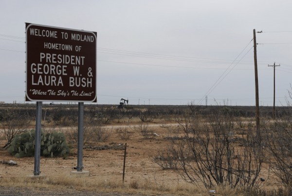
I left the interstate system finally at Midland, Texas, to take smaller roads up to Carlsbad, New Mexico. My sister jokingly suggested I should look up George Dubya Bush while passing through Texas. The best I could do was to snap a shot of a sign at the edge of Midland proclaiming the city’s claim to fame – the hometown of George W. and Laura Bush. The sign was surrounded by tossed beer bottles, stubbly cacti, and there were a few oil wells in the distance. I wonder what kind of impact this sparse environment had on the former president.
Even the smaller roads I took were mostly four lanes with nice straight, flat lines and comfortable speed limits of 75 mph (120 km/h). No need to speed, even though there were few places cops could hide. This is certainly oil country and you can smell the crude as you drive through.
Crossing into New Mexico, the communities seemed poor with small, ramshackle houses, even though they were surrounded by oil wealth.
Wednesday, December 23, 2009
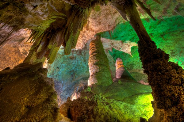
It was a crappy cool rainy day, which made it a perfect day to visit the caverns at Carlsbad. Outside, it was a cool wet 6°C with blowing winds. In the caves, it was comfortable and closer to 16°C. I’ve visited a number of caves around the world in places like Belize, Guatemala, Mexico and Slovenia. These caves were very impressive for their immense size and huge rooms. Although some rooms contained quite a number of “decorations” of stalactites and stalagmites, these caves were probably not as impressive in that regard as some others I’ve seen. They were tastefully lit with plain lighting, and there was an elaborate network of walkways that made much of the caves wheelchair accessible. There were no toilets underground, and had I known that I might as consumed less coffee that morning, but fortunately there was an elevator at the midway point back to the surface. I walked a couple miles underground and took a number of photos with a tripod.
Desert communities aren’t designed to handle volumes of rain, and when I drove back into Carlsbad, a number of the intersections were flooded and vehicles drove through streets like rivers. I carried on north to Roswell, which is repeated to be the site of a UFO crash in 1947. They’ve exploited this for tourism, and there are shops with pictures of little green men with big heads. There is an interesting museum documenting the incident and exploring the UFO phenomenon in general. It has newspaper clippings from the time, photographs of people involved, and affidavits signed by people who were either direction or in direct witnesses to events. I maintain an open mind but healthy skepticism about various UFO claims. In the time I spent there, I didn’t see anything that absolutely convinced me this was a UFO and not some other incident, for example the failure of the weapons test. I was convinced however, that the official explanation that it was simply a weather balloon was a hoax, and there was an official cover-up of what did actually happen.
When I left the museum it was snowing hard and the roads were slushy. I had planned to continue on to Alamogordo, but that would have entailed driving a couple hours in the dark on a mountain road in the snow. So instead, I got a motel in Roswell. That meant I would not be able to see White Sands National Monument at sunrise the next morning as I had hoped.
Thursday, December 24, 2009 (Christmas Eve)
There was still snow and ice on the ground when I left Roswell. The motel woman said snow that stays on the ground is very rare there. After crossing the scenic mountains, I arrived at White Sands National Monument. The sand dunes are fine gypsum sometimes packed quite hard, and sometimes soft. I took a couple trails over the dunes looking at the small scraggly vegetation that survived among them, and reading plaques about how animals survive there on little moisture. The glaring white in the sun often looked like snow, except it was much warmer.
From there I drove directly westward, through Deming, and into Arizona. My plan was to make it to Chiricahua National Monument. Here I experienced the folly of blindly following a route suggested by the GPS. Had I noted more carefully on one of my maps, I would have seen that the route to GPS was trying to take beyond was marked “closed in winter”. At first I was on a nice flat paved road heading through open rangeland and crossing periodic cattle guards, or “Texas gates” as they’re called in Alberta. Soon the road turned to gravel and I began to climb higher into the mountains. The road got narrower and narrower and rougher and rougher and I passed through a semi-ghost town called Paradise and noticed there was a lot more snow around. The road got steeper and steeper, the snow got deeper and deeper, and the mud got thicker and thicker. On one particularly steep stretch, my wheels spun and I realized it would be stupid to continue further. The road was too narrow to turn around, so I had to descend about a half a kilometer in reverse before I found a safe place to turn around. I retraced my route, and as it got dark, I realized my best bet would be to find accommodation in the town of Willcox and head for Chiricahua early the next morning.


